Linden Green Line
What is the Linden Green Line?
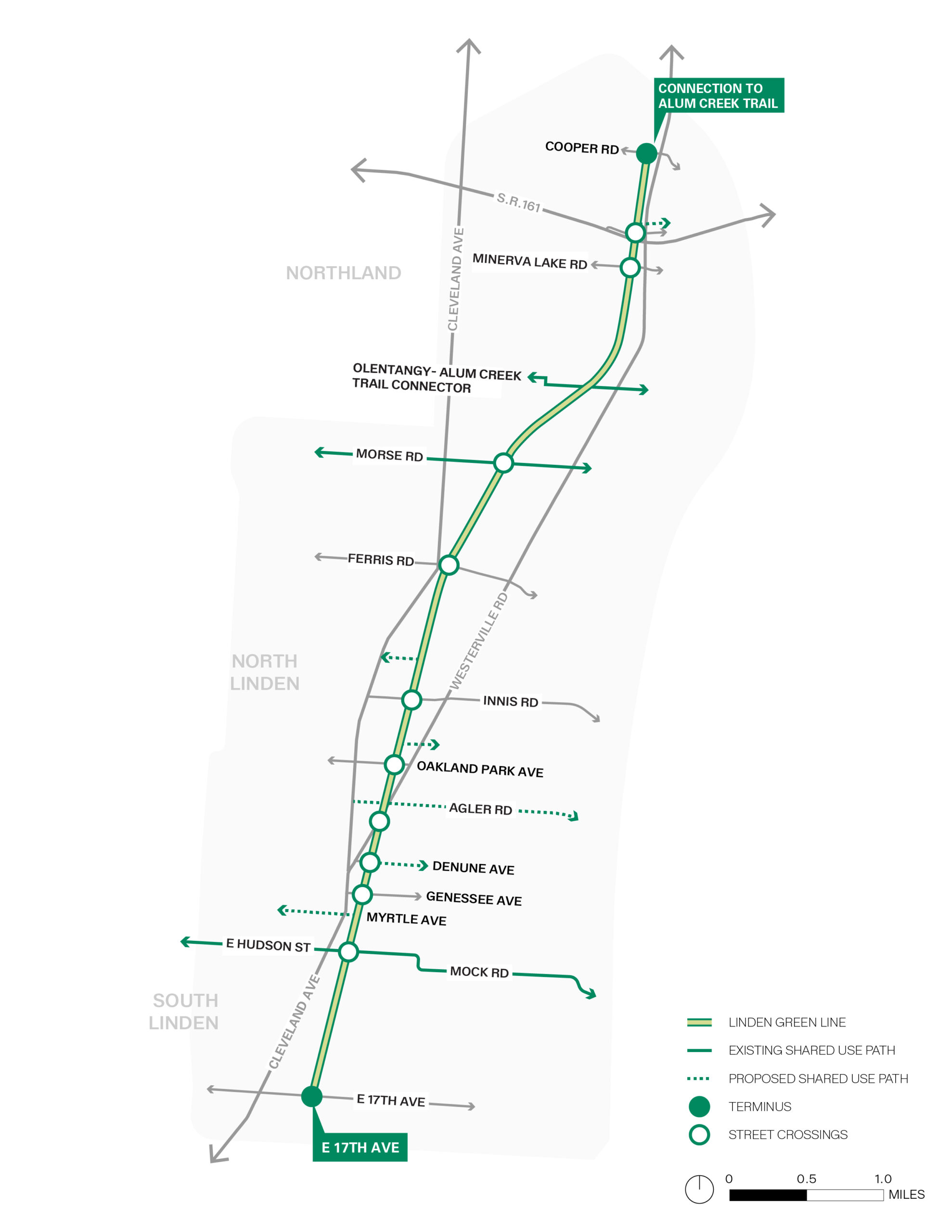
The Linden Green Line is a 58-acre linear park that aims to connect neighborhoods and ecosystems while generating new social and economic benefits. The Linden Green Line will follow 7 miles of former rail corridor spanning the Linden and Northland neighborhoods. Today’s abandoned rail corridor will be transformed into publicly accessible spaces for walking, biking and recreation.
Now entering the design phase, Columbus Recreation and Parks Department and WXY architecture + urban design (WXY) are leading an inclusive, participatory process that invites residents, business owners and community groups to help shape the future of the Linden Green Line.
The development of the Linden Green Line is made possible through funding from the City of Columbus, a federal BUILD grant, and LinkUS funds from the Central Ohio Transit Authority (COTA).
Take a Tour
Connecting Communities
This transformative project will connect:
- 3,000 businesses
- 19 schools
- 4 community centers, including Linden Community Center
- 10 parks, including Kilbourne Run Sports Park
- 135 miles of regional trails
The Design Team
To further develop the vision and design for the Green Line, the department has hired WXY, a nationally recognized architecture, urban design and planning practice. WXY has partnered with a collective of largely Columbus-based planning, design and engineering firms, including Arcadis Engineering, EDGE Landscape + Planning, EP Ferris, James Lima Planning + Development, Murphy Epson, RAMA Consulting, Lawhon Associates, MAD Scientist Associates, Catalyst and CTL.
Project Area
The Linden Green Line project area encompasses the former rail corridor that runs somewhat parallel to Cleveland Avenue and Westerville Road, along with key intersections, community assets and institutions that are adjacent or nearby. As part of the overall design effort, the team will look at how the Linden Green Line can support community growth, support broader conservation and connectivity goals, and anticipate future needs.
Project Timeline
The Linden Green Line design is currently in development. Over the next several months, community members are invited to take part in a series of workshops, events, and an online survey to share ideas and feedback. Your input will help shape the future design and character of the Linden Green Line.
Note: Below is a general project timeline. As the project design progresses, the timeline will be updated with additional details.

Project Materials
Key Dates
June 17, 2026
We will be holding a third public open house on Wednesday, June 17, to learn about the final concepts created for the Linden Green Line, based on your input! Join your friends, family and neighbors for a community cookout to celebrate as we move into the next phase of the project. Stop by the Maloney Park Shelter on June 17, from 5-7 p.m. Maloney Park is located at 1701 Joyce Ave, Columbus, Ohio 43219. RSVPs aren’t required but are strongly encouraged – RSVP today!
April 22, 2026
A second public open house will be held at Linden Community Center, located at 1350 Briarwood Ave., Columbus, 43211, on Wednesday, April 22, from 4:30-7:30 p.m. RSVPing is not required but encouraged – let us know if you will be attending!
Jan. 14, 2026
A public open house will be held for the Northland community on Wednesday, Jan. 14, 2026, from 5:30-7:30 p.m. This will be held at Woodward Park Community Center, 5147 Karl Road, 43229. More than 40 people attended. Check out media coverage of the event!
Jan. 13, 2026
A public open house will be held for the Linden community on Tuesday, Jan. 13, 2026, from 5:30-7:30 p.m. This will be held at Douglas Community Center, 1250 Windsor Dr., 43211. Approximately 60 people attended. Check out media coverage of the event!