Scioto Trail Extension Study
Scioto Trail Extension Study
Fifth Avenue to Trabue Road
About the Study
In 2020, Columbus Recreation and Parks Department sponsored a biking and walking study for the area from Fifth Avenue to Griggs Park, between US 33/Riverside Drive and McKinley Avenue/Dublin Road.
The purpose of the study was to explore different potential alignments of the Scioto Trail extending north to improve walking and biking facilities between Fifth Avenue and Griggs Park. The alignments were broken up into two segments: potential trail alignments from Fifth to Trabue Road and potential trail alignments to extend further north from Trabue Road to Griggs Park/Dublin Road.
Feedback from the public on the trail alignments was received in August/September 2020. The study was completed in April 2021 and recommended trail Alignment E from Fifth Avenue to Trabue Road be further developed. Future trail projects north of Trabue Road will continue to advance as part of the Central Ohio Greenways regional trail planning efforts.
Project Update and Next Steps
Columbus Recreation and Parks Department is currently focusing on further developing Alignment E, the Scioto Trail extension from Fifth Avenue to Trabue Road. During this phase, environmental studies and additional public engagement will occur to determine more specific details on the route. Over the course of this study, the alignment may be adjusted based on field work and feedback.
Environmental Studies
Environmental studies will be completed to identify wetlands and other important habitat, if any, for consideration during design of the trail alignment. The findings will be summarized in a report.
Public Engagement
Nearby neighbors, home owners associations, area commissions and other interested groups will be engaged to solicit additional feedback on the proposed trail alignment. It is anticipated that meetings will be set up with surrounding neighborhoods to discuss questions, comments and concerns for consideration during design of the trail alignment.
Update as of January 2024:
Frequently Asked Questions
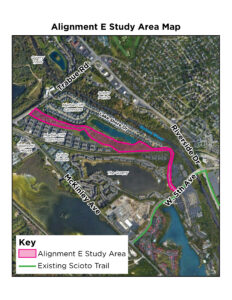
Why was Alignment E selected?
Alignment E was selected as the most preferable and viable trail alignment based on a comparison of greenway characteristics (natural, scenic, safe, quiet, direct), environmental impacts, property impacts, alignment with upcoming Scioto Trail projects by partner agencies and costs. A full analysis matrix comparing the alignments can be found in the Fifth to Griggs Biking and Walking Study.
Why is the trail extention needed?
To Improve Connectivity
Major barriers exist in the project area including the Scioto River, a railroad corridor, disconnected residential developments, gated residential developments and roadways. Providing a dedicated trail to connect the existing Scioto Trail to Quarry Trails Metro Park and beyond will provide walkers, cyclists, runners, and rollers of all ages safe access to the greater regional trail system, Griggs Park, and other popular destinations.
To Improve Mobility
Most roadways in the study area do not have continuous sidewalks or paths for active transportation users. An off-road trail (like the alignment proposes) will provide connections for all levels of users – from those who use the existing trail to new trail users in surrounding neighborhoods. Providing safe, easily accessible trails for all levels of cyclists and pedestrians will encourage more trips and overall usage.
What feedback are you looking for now?
We’re hoping to hear about any concerns or areas to avoid in the trail alignment study area. We would also like to know if connections to the trail are desired, and if so, where those connections should be. We’re open to any feedback you would like to provide or anything else you would like the project team to know.
Alignment E Study Area Map
Submit Your Comments
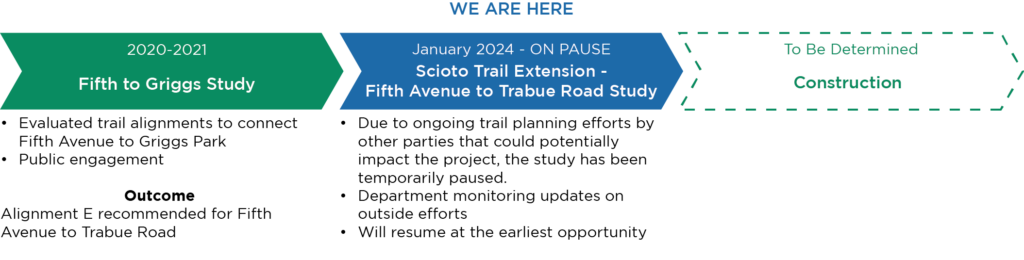
Project Timeline