Tree Canopy Assessment
The Columbus & Franklin County Tree Canopy Assessment: 2011-2021 report is the first comprehensive study of our region’s trees, as well as their change over time. The City of Columbus and Franklin County partnered to conduct a new and expanded tree canopy assessment. Instead of exclusively studying tree canopy within City of Columbus boundaries, as was done in a previous 2015 report, this Tree Canopy Assessment includes the entirety of Franklin County, which in itself includes 16 cities, 9 villages and 17 townships. Urban forests are regional assets, and the benefits they provide are not limited to jurisdictional boundaries.
What’s a tree canopy assessment?
A tree canopy assessment measures how much of a city’s land is covered by trees, as viewed from above. It shows the tree canopy a community has, how it has changed, and where there is room to plant trees.
This study assessed tree canopy for Columbus and Franklin County over the 2011-2021 period.
Why study tree canopy in Columbus and Franklin County?
Central Ohio is facing intense population growth and development pressures over the next decades, as well as climate change and public health challenges. Trees are integral to our residents’ quality of life because they provide benefits such as filtering and cooling the air, producing shade, and increasing positive mental health outcomes. Understanding our regional urban forest is an important step to prioritizing, expanding, and growing tree canopy over the coming decades.
Learn More about the Columbus & Franklin County Tree Canopy Assessment: 2011-2021 Report
Highlights from the 2011-2021 Tree Canopy Assessment
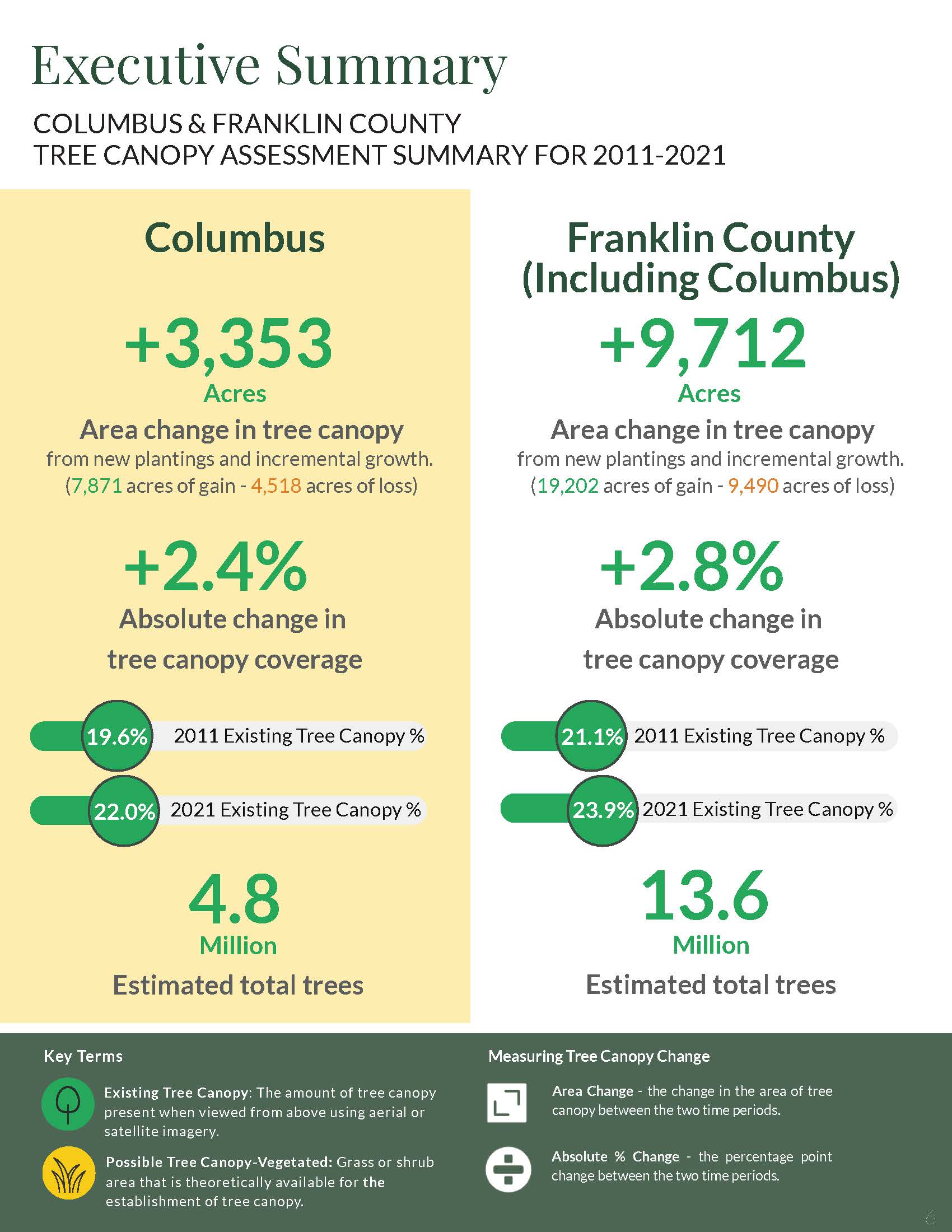
City of Columbus
Columbus’ tree canopy grew by 2.4% over a ten-year period, from 19.6% in 2011 to 22% in 2021. There are approximately 4.8 million trees growing within Columbus boundaries, meaning there are five trees for every Columbus resident.
There was widespread gain (7,871 acres) and loss (4,518 acres) in canopy cover, amounting to net gain of 3,353 acres from new plantings and incremental growth. The majority of canopy is on residential and parks and open space properties. The right-of-way (ROW) also played a key role in canopy gain. ROW, an important type of land use that is managed by the City, grew by nearly 480 acres of canopy. Tree removals on suburban and urban residential land caused the most canopy loss (2,175 acres). Twenty four communities in Columbus fall below the citywide canopy cover of 22%, with Italian Village and Downtown having the least canopy, at approximately 12%.
Franklin County
Franklin County’s tree canopy grew by 2.8% over a ten-year period, from 21.1% in 2011 to 23.9% in 2021. There are approximately 13.6 million trees growing in Franklin County, meaning there are 10 trees for every County resident.
There was widespread canopy gain (19,202 acres) and loss (9,490 acres). The tree canopy across the 41 cities, townships, and villages in Franklin County varied from 14.9% to 56.5%. Land use history, invasive species, urban forestry initiatives, natural processes, and landowner decisions all influence the current state. The majority of the County’s canopy is located in parks and open spaces, as well as residential property. These areas should play a key role when planning for canopy growth. The type of land associated with tree canopy loss varies from removal of individual trees in backyards to clearing of patches of trees for new construction. Suburban residential land had the most loss (3,500 acres), but the gains in suburban lands (5,700 acres) outpaced loss, resulting in a net gain of canopy. There is room to plant more trees in the County, without removing hard surfaces, with an estimated 163,000 acres of possible tree canopy vegetated area.
Tree Canopy Fact Sheets for Columbus Communities
Check out the fact sheets on the current tree canopy, estimated number of trees and change over time for each of Columbus’ 41 communities.
Tree Canopy Fact Sheets for Columbus Council Districts
Check out the fact sheets on the current tree canopy, estimated number of trees and change over time for each of Columbus’ nine council districts.
Tree Canopy Fact Sheets for Municipalities in Franklin County
Check out fact sheets on the current tree canopy, estimated number of trees and change over time for each of Franklin County’s 40 jurisdictions.