Big Walnut Trail: Little Turtle to Alum Creek Trail
Big Walnut Trail
Little Turtle to Alum Creek Trail

About the Project
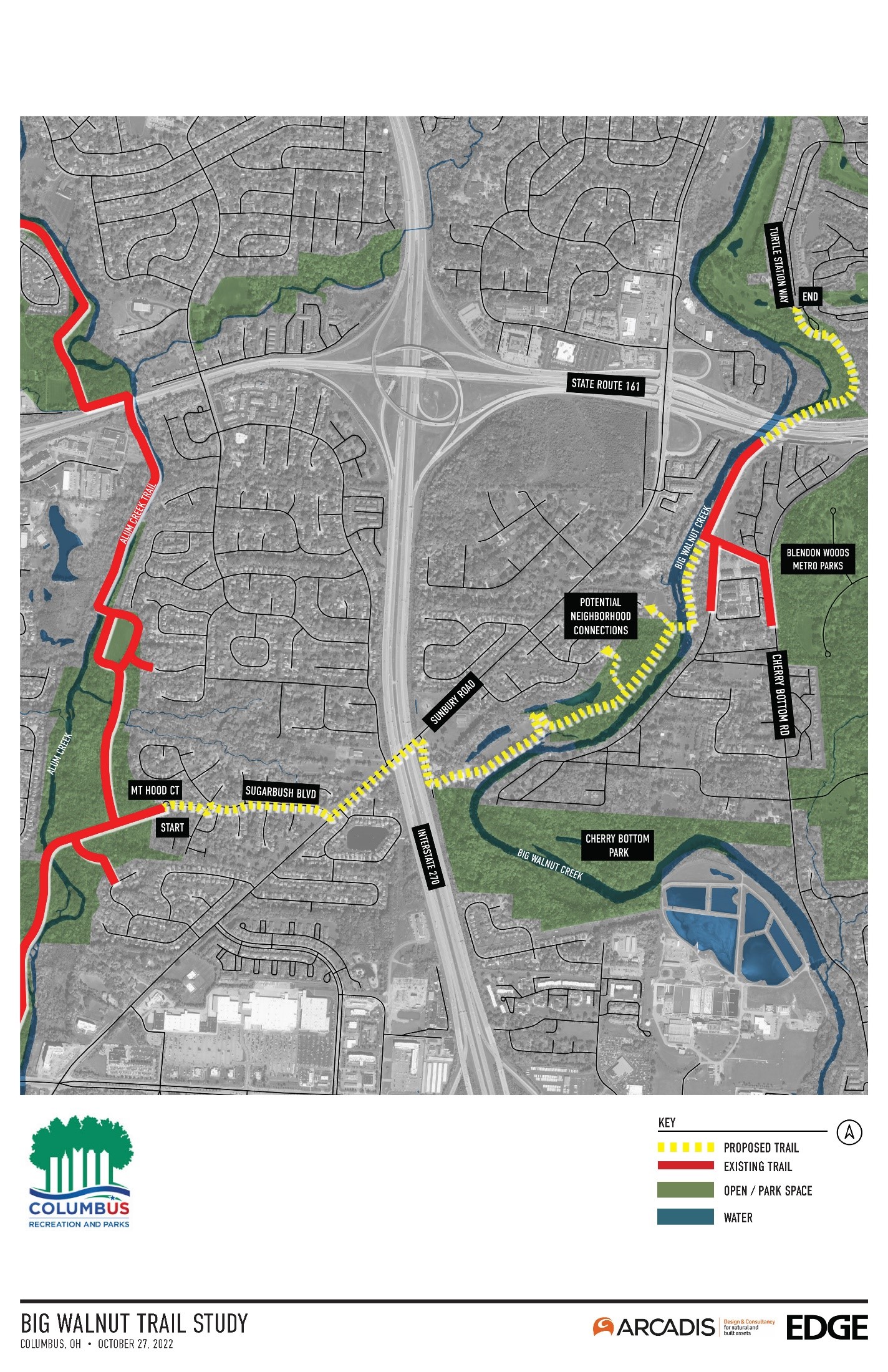
Columbus Recreation and Parks Department, in partnership with the Ohio Department of Transportation (ODOT), is constructing a dedicated 2.5-mile trail along the Big Walnut Creek corridor from Turtle Station Way, just north of State Route 161, to Mt. Hood Court, where the trail will connect to the existing Alum Creek Trail. The new trail will provide residents and users with year-round recreational opportunities, access to parks, neighborhoods, job centers, and bike and pedestrian connectivity to the central Ohio regional trail network. The trail will include boardwalk sections, on-street sections and a new bridge crossing Big Walnut Creek. The study is being funded in part by federal grant funding (Transportation Alternatives Program [TAP]) administered through the Mid-Ohio Regional Planning Commission (MORPC).
Schedule
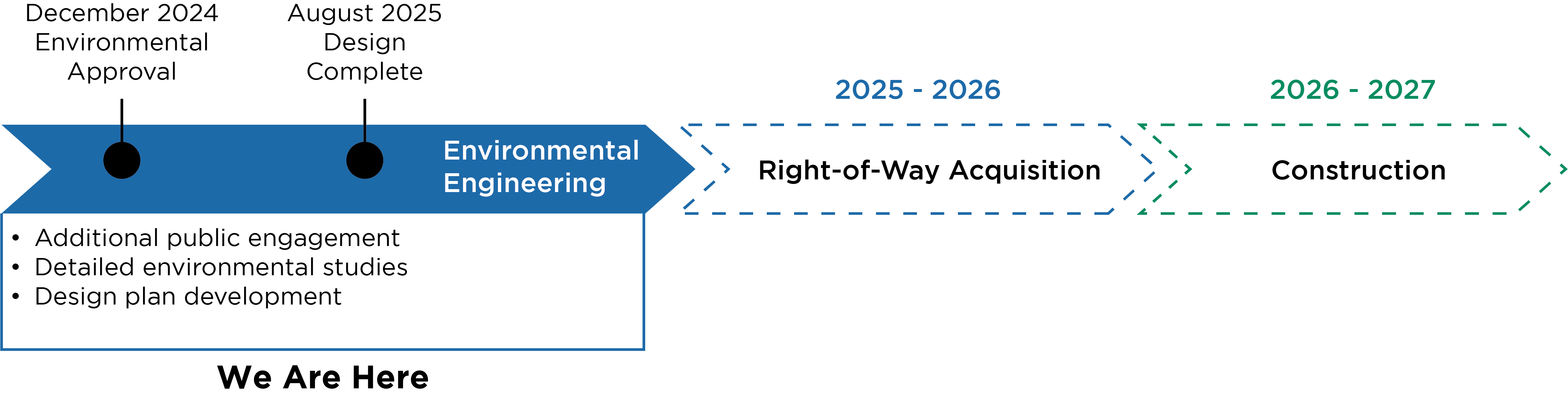
Background
Columbus Recreation and Parks Department worked with its partners within the Central Ohio Greenways area to develop a multi-year plan that creates a system of six regional trails within central Ohio, called the Greenways Five-Year Plan 2018-2022. The trails will be an interconnected system of over 135 miles of trails, the backbone of which is comprised of: Big Walnut, Alum Creek, Olentangy, Scioto, Blacklick Big Darby and Camp Chase. Part of the plan’s purpose was to also identify locations that lack connectivity between existing facilities. Currently, the Big Walnut Trail exists in numerous separate segments. From Little Turtle south to Sunbury Road, no trail or connectivity exists for several thousand residents living nearby. The connection between existing Alum Creek Trail and the extension of Big Walnut Trail are illustrated on the Greenways 2018-2022 overview map included in the Five-Year Plan. This proposed connection would service approximately 11,600 residents within a half-mile of the trail.
In 2021, Columbus received funding for construction of the trail, and has begun a study of the route, including natural resources, destinations, possible connections and existing topography and floodplain.
Why is the Trail Needed?
Makes Key Connections
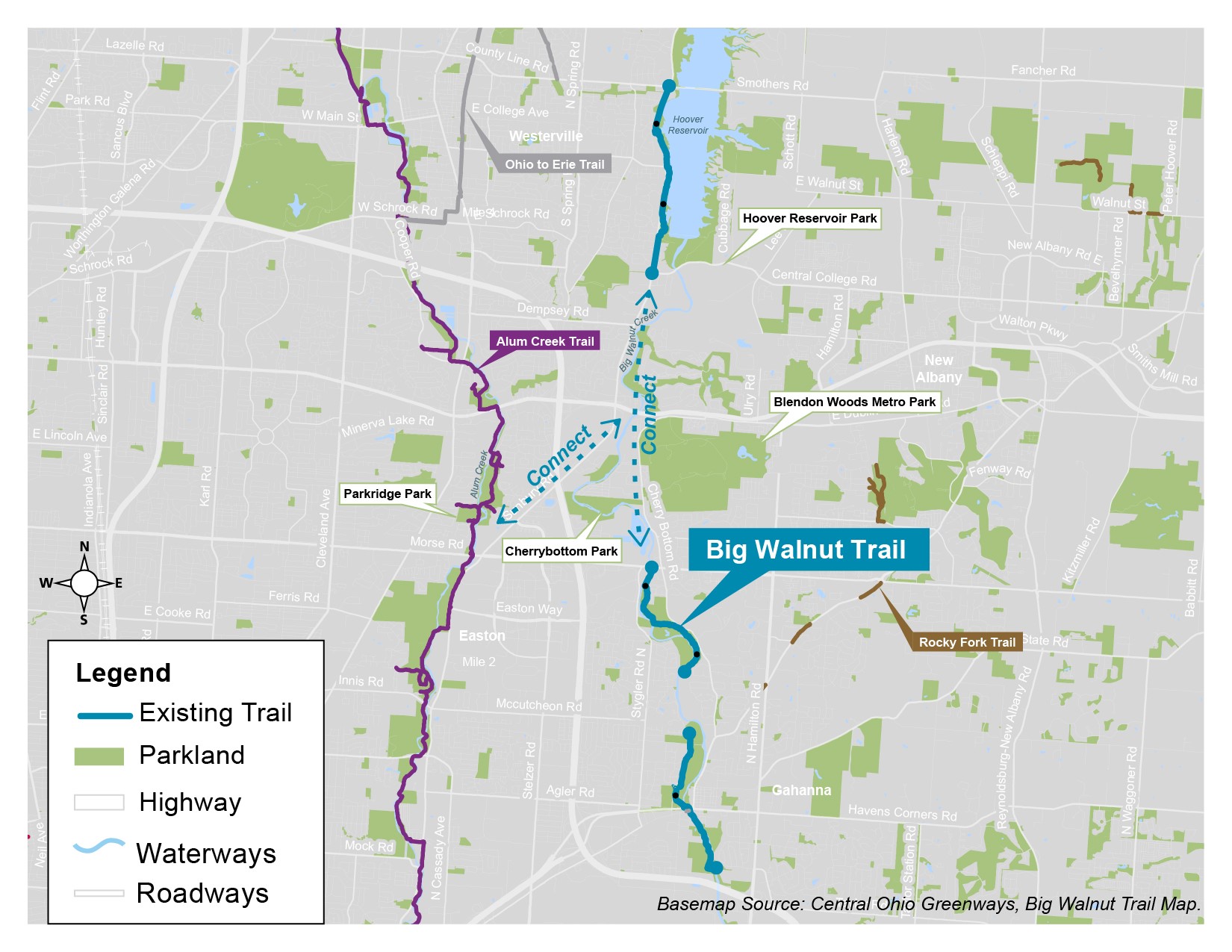
Providing infrastructure that links the northern two sections of Big Walnut Trail to each other and to the nearby Alum Creek Trail at Parkridge Park will provide active transportation users access to the greater regional trail system and advances the larger vision of a regional park system for the greater Columbus area. Providing system linkage for these trails would also provide for connections to Hoover Reservoir Park, Blendon Woods Metro Park, Cherry Bottom Park and parks along the 22-mile Alum Creek Trail. The Easton area would be less than 15 minutes by bike from the northern end of this project.
Provides a Safe, Easily Accessible Trail
Currently connections between Little Turtle and Alum Creek Trail can only be made by using surface streets, which range from moderate to high traffic volume roadways for motor vehicles. Some of these streets lack adequate pedestrian accommodations and are noted to be unsafe for average cyclists. An off-road trail (like the conceptual alignment proposes) will provide connections for all levels of cyclists – from those who use the existing trail to new trail users in surrounding neighborhoods. Providing safe, easily accessible trails for all levels of cyclists and pedestrians will encourage more trips and overall usage.
Removes Barriers
There are substantial barriers to walking and biking in this study area. While sidewalks exist in neighborhoods and along some streets, State Route 161 and Interstate 270 cut through the area, making nearby destinations unsafe to walk or ride to. One of central Ohio’s largest greenspaces, Blendon Woods Metro Park, is surrounded by thousands of residents, yet is accessed predominantly by car. The trail would remove these barriers by providing safe connections under these large, high-speed roadways.
Allows Access to Nature
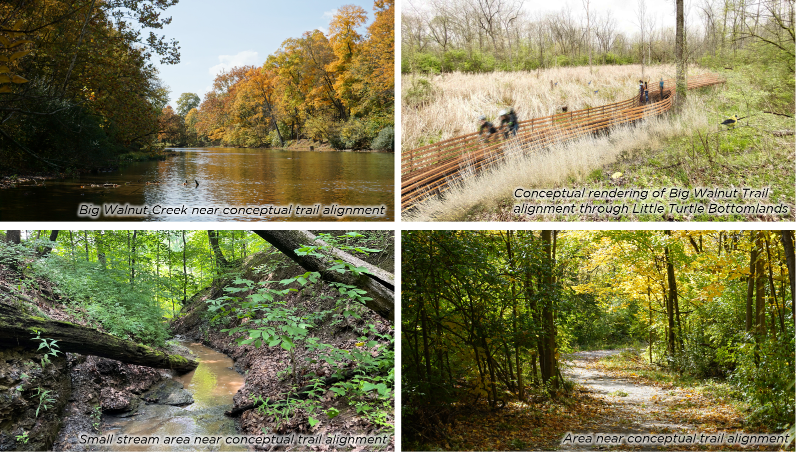
A dedicated trail will provide a safe way for users to connect to regional trail networks and parks. The location of the trail along Big Walnut Creek also provides users a connection to what is recognized as one of the most scenic, highest quality streams in central Ohio and other unique natural landscapes.
Improves Health and Wellness Opportunities
Regular physical activity, such as walking or biking, can help prevent serious diseases and health issues. Providing a well-connected trail makes regular exercise for all ages easy to incorporate into an everyday routine – whether it be for transportation, recreation or sport. More and more research has shown that exposure to nature (when in a safe environment) can also reduce stress and provide numerous other mental health benefits.
Conceptual Trail Alignment
The image below illustrates the preferred alignment to connect Turtle Station Way to the Alum Creek Trail at Mt. Hood Court.
Materials
- Big Walnut Trail Conceptual Alignment Graphic
- Big Walnut Trail Connectivity
- Big Walnut Regional Trail_Hoover to Three Creeks
- 2019-2024 5-year Greenways Plan
Public Engagement
Thank you to everyone who participated in the public comment periods for the Big Walnut Trail – Little Turtle to Alum Creek Trail Project. Your feedback during the initial comment period (Nov. 14–Dec. 2, 2022) and follow up comment period 2 (Nov. 13–Nov. 28, 2024) has been critical in shaping this important project.
The public comment period is officially closed. We appreciate the community’s valuable input and engagement throughout this process. To review the public comments and the department’s responses, refer to the PDF links below:
Stay tuned for updates as we work to enhance our trail network and community spaces!
F.A.Q.s
Will the proposed trail impact the Home Owners Association (HOA) at Shady Blossom Lane?
No, the proposal trail will not impact the HOA at Shady Blossom Lane. The trail will cross from CRPD parkland situated on the western side of Big Walnut Creek, located south of the HOA property, to the eastern side of the creek as it continues its northward direction.